December Hasn't Been Very Cold So Far...Will That Change?
WAIT, WASN’T DECEMBER SUPPOSED TO BE PRETTY COLD??
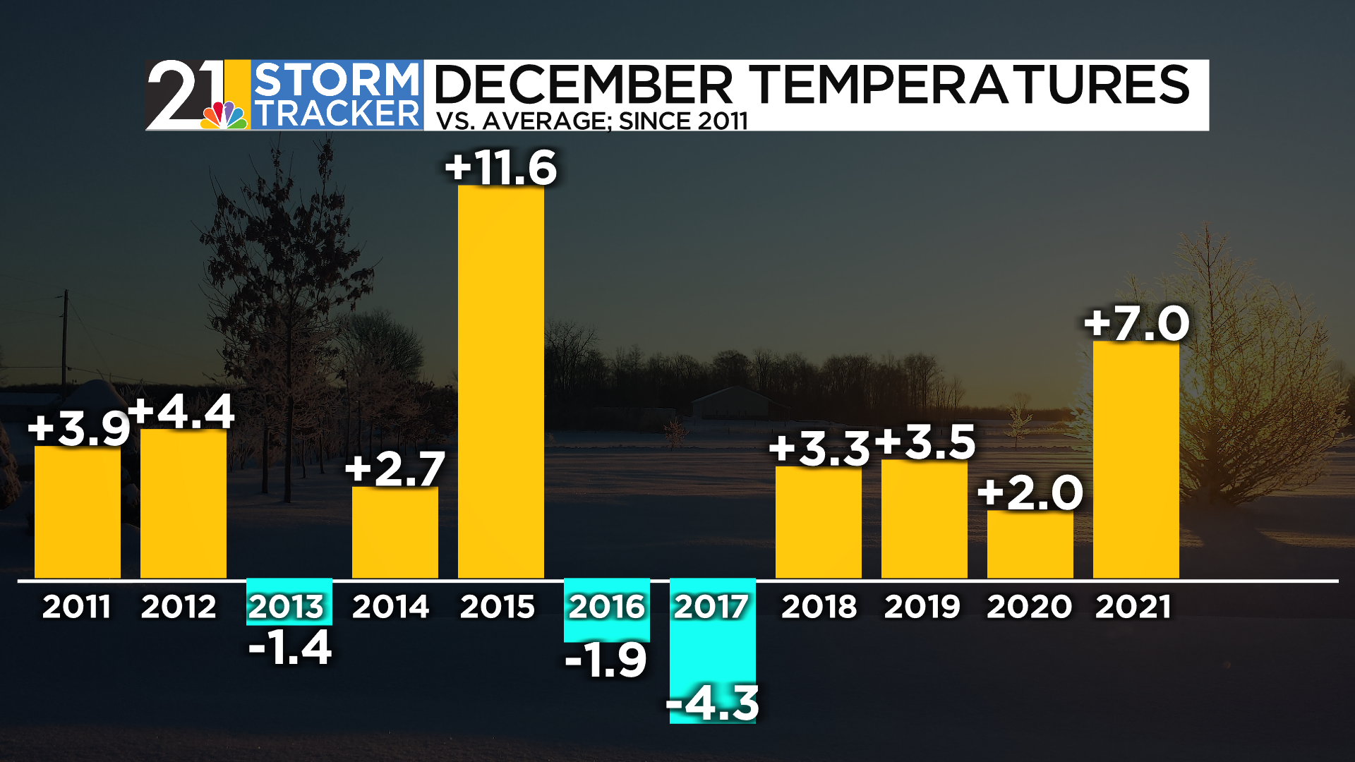
When I issued by annual Winter Forecast back on November 17, a key point of emphasis was the idea that this December had a good chance of bucking the trend of recent Decembers, which have been quite mild. We have not had a cold one in 5 years:
As you know if you have read/watched my seasonal forecasts, the forecast is constructed partly through the use of “analogs”, which are seasons in the past that we think have a lot of similarities to the one that is being forecast for. Toward the top of the list of analogs for this winter was 2010-2011, which started with an INSANE December…..it was the snowiest month on record here. Over 50 inches!

In late November of this year, it was becoming obvious that a monster “block” would form over the northern Atlantic. A block basically means a big ridge of high pressure at the jet stream level. This is a feature that can sometimes lead to a clod and stormy period in the eastern US. But this wasn’t just any old block. This was shown my the weather models to be the strongest block in the northern Atlantic since…drum roll…December 2010.
A ha! This idea of a cold December was likely to work out! And while we would never predict such an anomalous month as December 2010, we could begin thinking that this season would probably get off to a reasonably fast start.
Has it? Meh, not really. Temperature anomalies through the first week of the month:

Interesting how much that map, just 1 week into the season, looks like our overall winter temperature forecast:

SO WHY IS THIS DECEMBER TURNING OUT SO DIFFERENT THAN 2010?
First, it’s important to note that there is a LOT of December left. There will be changes and maybe some pretty big ones, before the month is through. But certainly the first 2 weeks of the month will go into the record books as pretty “not cold” in our part of the country.
This is serving as a reminder to everyone in the weather game that we can’t put all our eggs in one basket. A strong block over Greenland does not mean you can pencil in harsh cold over the East. Our weather is greatly influenced by what’s going on to our west, too. And the pattern over the Pacific and western North America has refused to “play ball” so far.
Let’s compare December 2010 and the first half of December 2022. This map shows the main weather features in the mid levels of the atmosphere in early December 2022. Note the strong blocking over the northern Atlantic. BUT, also note 2 other important features. A persistent ridge over the northern Gulf of Mexico and a persistent trough over the West Coast.

Now compare that to December 2010. That month, there was also the strong Greenland block, but also no ridge over the northern Gulf, and the trough out west was centered more offshore.

This December, the Gulf ridge is helping to deflect the cold to our west, while that trough on the West Coast is continuing to act like a funnel for the cold coming south out of Canada. In 2010, the lack of a Gulf ridge and the trough out west being centered farther west allowed cold air to charge south and east.
This general pattern is expected to continue for another week-10 days. Then, things can get more interesting.
PATTERN CHANGE?
There is general model agreement that the pattern will become more favorable for cold in the East during the last 2 weeks of December. The magnitude of the cold is certainly in question though. At least it is around here,
In the lead up to Christmas, that ridge over the northern Gulf should break down, allowing for the “damn” to break east of the Rockies. The cold can finally come east. But there are model differences when it comes to the West Coast. If the jet stream buckles and a ridge pops along the coast, the taps can really become wide open for arctic cold to come all the way east. This modeling (the European) from earlier this week has that idea:

Other modeling is less bullish. If a trough lingers out west, cold will continue to infiltrate the Rockies and West Coast and will come east in a more “diluted” i.e. “less cold” form.

Either way, it should get a fair amount colder from around the 16th-19th onward. Model temperature anomalies show coast-to-coast cold in the week before Christmas:


WHITE CHRISTMAS?
Ok, so it is going to get colder. Does this mean a White Christmas? We don’t know that yet. But we can say the odds of snow on the ground on December 25 will almost certainly be higher than at any point over the next week or so.