On To Spring! Review Of Putrid Winter Forecast & A Look Ahead
In this post we will eulogize the winter 2022-2023 forecast and then never, ever speak of it again.

I am no huge fan of snow….shoveling it, driving in it, etc. So, on one hand I am happy with this season’s exceptional warmth and lack of snow so far. On the other hand, BOY DO I HATE GETTING A FORECAST WRONG. Especially one that involves the kind of hours of research and hard work as the annual winter forecast. I mean, this is the nature of the beast; seasonal forecasts are hard and sometimes you are going to fail spectacularly. But it still stings. We will treat it as a big learning opporunity and move on.
FIRST, THE STATS
No all-time records were set this winter, but we finished near the top in several categories.
It was the 3rd warmest winter on record:

The January/February combo was the 2nd warmest on record.

We are not done counting snowflakes this season but just for December-February….it was one of the least snowy periods on record for our area.

The numbers would have been even more impressive if it were not for the cold snap around Christmas.

So…what happened with the forecast???
First of all, hey we did allow for a 2%-5% chance of this kind of winter happening. Better than zero!
Warm winters are more common in La Ninas rather than El Ninos, but our two warmest were STRONG El Ninos. This was the 3rd warmest winter on record and was a weak La Nina. Unusual.

JANUARY KILLED THE WINTER (AND WINTER FORECAST), MORE SO THAN FEBRUARY
In a winter that takes place during a La Nina, a mild/warm February is not uncommon at all. A ridge of high pressure likes to park over the southeastern US/Carribean and this feature can deflect much of the cold to our west.
Often December/January is the “make or break” period for a winter forecast in a La Nina…and this year January just broke it completely. December featured a vicious cold snap around Christmas but the month as a whole was not particularly cold.
Weather headlines in January included “bomb cyclones” and “atmospheric rivers” impacting the West Coast. If we are talking about that kind of weather out west, chances are we are talking about the opposite in the East.
The seeds of our balmy January were actually planted in December and in ASIA of all places. It’s amazing how connected things can be on this planet of ours. You really do have to look globally to forecast locally. So what happened?
“EAST ASIA MOUNTAIN TORQUE”
Say what. I’ll be honest, this is a term/phenomenon that I had not out much though into until this winter. Basically it goes like this: very strong high pressure presses southward through Asia and air plies up at the very big, very tall Himalayan mountain range. This can actually slow the rotation of the earth a little, and the atmosphere compensates for this by speeding up the wind at the jet stream level. The jet stream over the Pacific elongates and intensifies…which can bring lots of storms to the western US, The continent gets flooded by mild Pacific air and not arctic air. This sequence of events is not that uncommon, but the midwinter event was particularly strong. This, combined with the jet stream being further “goosed” by conditions over the Indian Ocean/southwest Pacific, created a perfect recipe for a prolonged warm stretch during the heart of winter. It doomed many a winter forecast. Unfortunately, a rare event like this is not very predictable.


The rip roaring Pacific jet in January
LOOKING AHEAD TO SPRING
Meteorological Spring is March-May. Will the winter pattern continue into spring? It does not seem that way! The data is looking mighty chilly for mid March and possibly beyond.

The outlook for April and May is less certain, although at this early stage I would not be surprised in at least early April was on the cool side. The outlook from the Climate Prediction Center favors warmth, but that might rely heavily on a mild May:

Precipitation wise, wet conditions are favored in spring, I suspect that’ll mainly be the case in the first half of the season.

SUMMER? EL NINO??
La Nina has persisted for 3 straight years now, but it’s time is about up. El Nino is likely to emerge at some point over the summer or early autumn. A sooner onset of El Nino could make for a much different summer than if it waits until later this year.
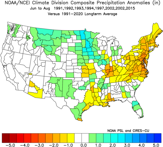
Recent summers with El Nino:

The signal is not as strong here as in other parts of the country, but the overall “flavor” of El Nino summers is cool-ish.
If we have ENSO-neutral conditions over the summer (neither La Nina or El Nino), the map looks quite a bit different:

Again, not as strong of a signal locally, but definitely some hotter risks in much of the U.S. Precipitation is even more interesting. Rainfall anomalies during El Nino:
A dry signal for us. ENSO neutral looks like a mirror image of that map:

It seems to me that El Nino is likely to come on fairly fast in the coming months, so I lean in the direction of it being on the dry side this summer.
In recent years, the “aridity index”, which factors in recent temperature and precipitation trends, can be a useful tool in early spring when trying to determine where future dry areas are likely to be. Interesting that the aridity index right now looks fairly similar to the composite precipitation map of recent El Nino summers.

Thanks for reading! We’ll do better next year.