Some Perspective On Next Week's Late-Season Heat Wave
More than likely you are aware that we have some unusual late-season heat coming our way early next week as September ends and October gets underway. But HOW unusual will this be? I thought I’d offer a few thoughts and stats on that subject.
THE SETUP
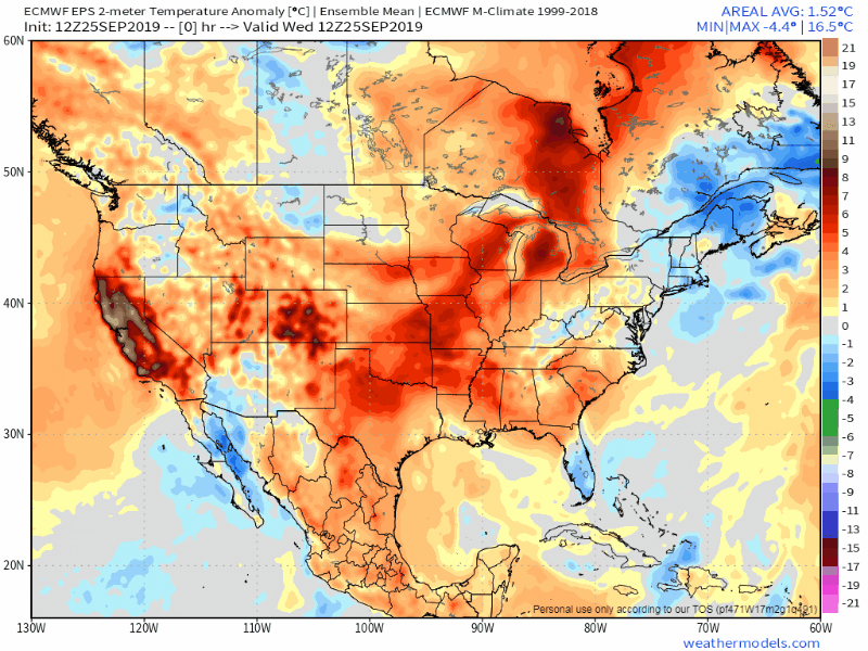
The pattern across North America will become highly amplified over the weekend early next week, as a strong trough of low pressure digs across the West. This will cause a huge, anomalous ridge of high pressure to pop across the East. If this were July, triple-digit heat would be common under the ridge and we’d probably be looking at mid 90s around here. It’s not midsummer anymore so temperatures can only get SO warm….but we’ll still see readings as much as 20-24 degrees warmer-than-average.

HOW HOT?
I think we have a legitimate chance of seeing 90 degrees on Tuesday, the first day of October. This would not only be a record high for that date, but an ALL_TIME record high for October. In recorded history, our area has not seen 90° after September 29.

The average date of the last 90 of the year? In the middle of August!

Tuesday is the day in which 90 is most likely, but Monday and Wednesday will also be very warm/hot.

WARM SEPTEMBERS VERY COMMON LATELY
Over the last 30 years, September has actually seen the LEAST amount of warming compared to every other month. BUT, the last 5 years have been a different story. 2015 didn’t crack the top 10 but it was the 13th warmest. September 2019 will finish in the top 10 and perhaps even top 5.


CLIMATE CHANGE LINK?
No single weather event or weather pattern can be directly attributed to climate change, especially while it is happening. Peer-reviewed study is needed and that takes time. That said, the rapidly warming atmosphere (and oceans) greatly increases the odds of extreme weather. The analogy I like to use is this: in the steroid era of baseball, every home run that was hit by Sammy Sosa, Barry Bonds, etc did not occur simply because they were using steroids. Many of those home runs would have occurred anyway. But the fact that they were using performance-enhancing drugs increased the odds that any given pitch would result in a home run.
Right now the planet “is on steroids” and so the odds of extreme weather patterns occurring is higher.

By the way, the oceans are absorbing a large portion of the heat. They are warming at an alarming rate and it IS impacting weather patterns. The oceans cannot sustain this and eventually the warming of the atmosphere is likely to make a significant jump upwards.
An alarming new report came out this week. It’s worth a read: https://www.nbcnews.com/news/world/cut-emissions-avert-catastrophic-sea-level-rise-u-n-study-n1058466
WHEN CAN I TURN INTO AUTUMN MAN/WOMAN?

The heat wave will break during the second half of next week and it’ll feel LIKE FALL next weekend. Probably some highs in the 60s and lows in the 40s. Not crazy cold…in fact just back to normal but it’ll finally feel crisp and cool for a while.
DOES THIS MEAN ANYTHING FOR WINTER?
Nah, not really. Late summer/early fall weather patterns generally do not have a strong correlation to wintertime regimes. Stay tuned for my annual winter forecast in late October/early November.