Winter Review & The Spring 2024 Forecast
Winter 2023-2024: Another Absolute Dud
Meteorological Winter is the months of December, January and February…the three coldest months of the year. And yet: the season was anything but “cold”. We had a quite cold 8 day stretch in January annnnnd…well that’s pretty much it.

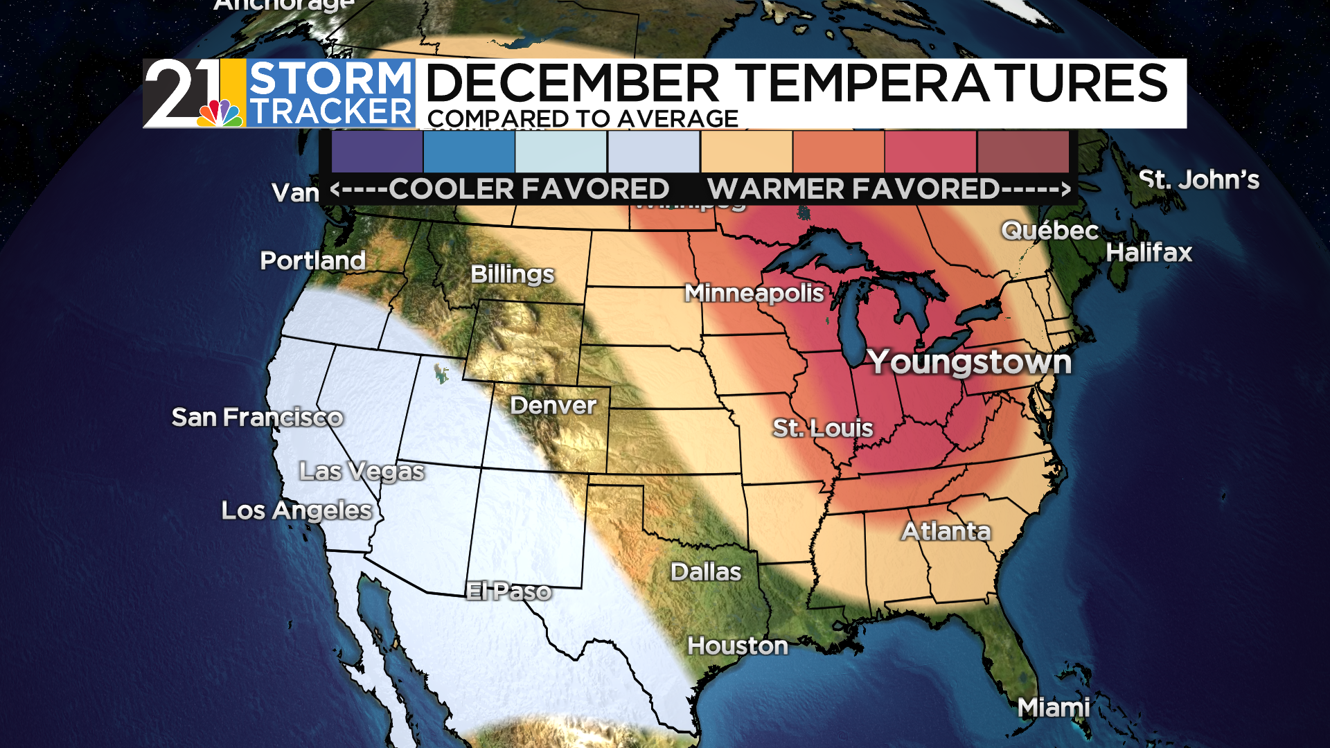
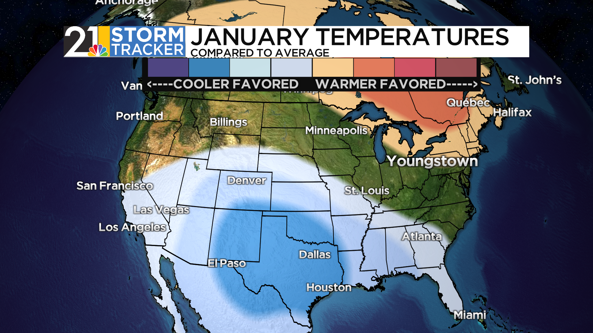
December was the 2nd warmest on record…February in the top 5 warmest on record. January was 3.7 degrees warmer-than-average and it was the MOST “normal” month of the three.
All in all, this will go into the record books as the 2nd warmest winter season on record here. Was that expected? No, but perhaps it should have been.


The Winter Forecast
Every year, I issue a winter forecast around the first week of November. Seasonal forecasts are much different than the daily, run-of-the-mill forecasts that meteorologists come up with every day. Seasonal forecasting involves looking at lots of historical data to find “analogs” for the upcoming season. Our list of analogs this year was comprised of El Nino years that had other similarities to this year (I’ll spare you all the details). The common theme among the analogs: a warm December, a cold February. January would be somewhere in between.
The thing is: the forecast was doing well! Until late January, that is. Let’s see how we did.
December forecast and verification:

January forecast and verification:

Pretty happy with how those turned out. But, when the mid-January cold snap ended, a “blow torch” pattern evolved and the February forecast was ugly.


Oops. So what happened?
I think forecasters (myself included) were tripped up by the state of the oceans, especially the Pacific. El Nino was going to be strong, but because nearly the ENTIRE Pacific is super warm, the temperature difference between the ENSO region (where El Nino is) and the other areas would be lower than El Ninos of the past. The conventional wisdom was that El Nino, while strong, would not necessarily behave like a strong El Nino.
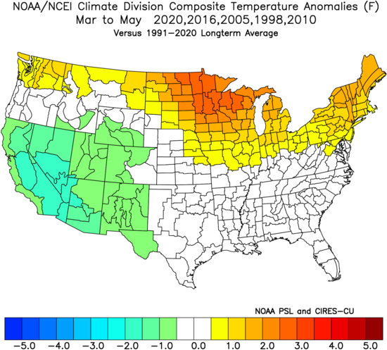
Turns out, it pretty much did. Had the February forecast relied on analogs that included just the strong to very strong El Ninos, it would have a been a good forecast. Check out the Februarys of the most recent strong Ninos:

Looks very similar to February 2024.
Here were the percentage chances we gave for outcomes this winter.

So, the grades for the forecast:

Snow is sort of an “incomplete” forecast as we are not done with it yetm but of course snow amounts are not only below average…but WAY below average.

On To Spring! What To Expect
Here’s what we know: Spring (March-April-May) will get off to a warm start. The first 2 weeks of March are likely to be a far amount warmer-than-average.
Beyond that? Maybe a horse of a different color. Same as with the winter forecast, we will rely on “analogs” as the foundation of our seasonal forecast. This time we are mainly interested in years in which we had a rapidly fading El Nino during the spring season. A couple of the analogs were not very strong El Ninos (like this year’s), but did have the negative phase of the “Pacific Decadal Oscillation” like we do now.
Not a very “cool” looking map, but maybe not as warm looking as you would expect given the warm start to the season. That’s because April and especially May have a cooler look:


What about rain? Spring is of course, an important time of the year for planting. Temperatures are important, but the amount of rain we see during this 3 month stretch can set the tenor of the growing season.
I am concerned about a drier than average Spring. The analogs contain a fairly stout “not wet” signal:
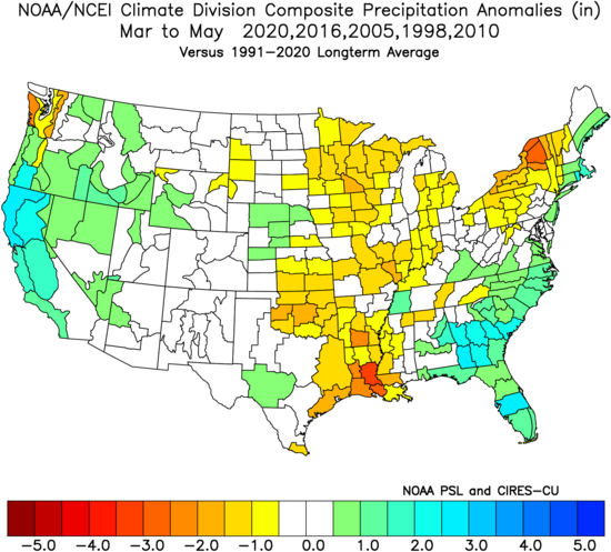
In the years that make up that composite, a couple of them were quite dry. Only one (2020) was fairly wet in our area.
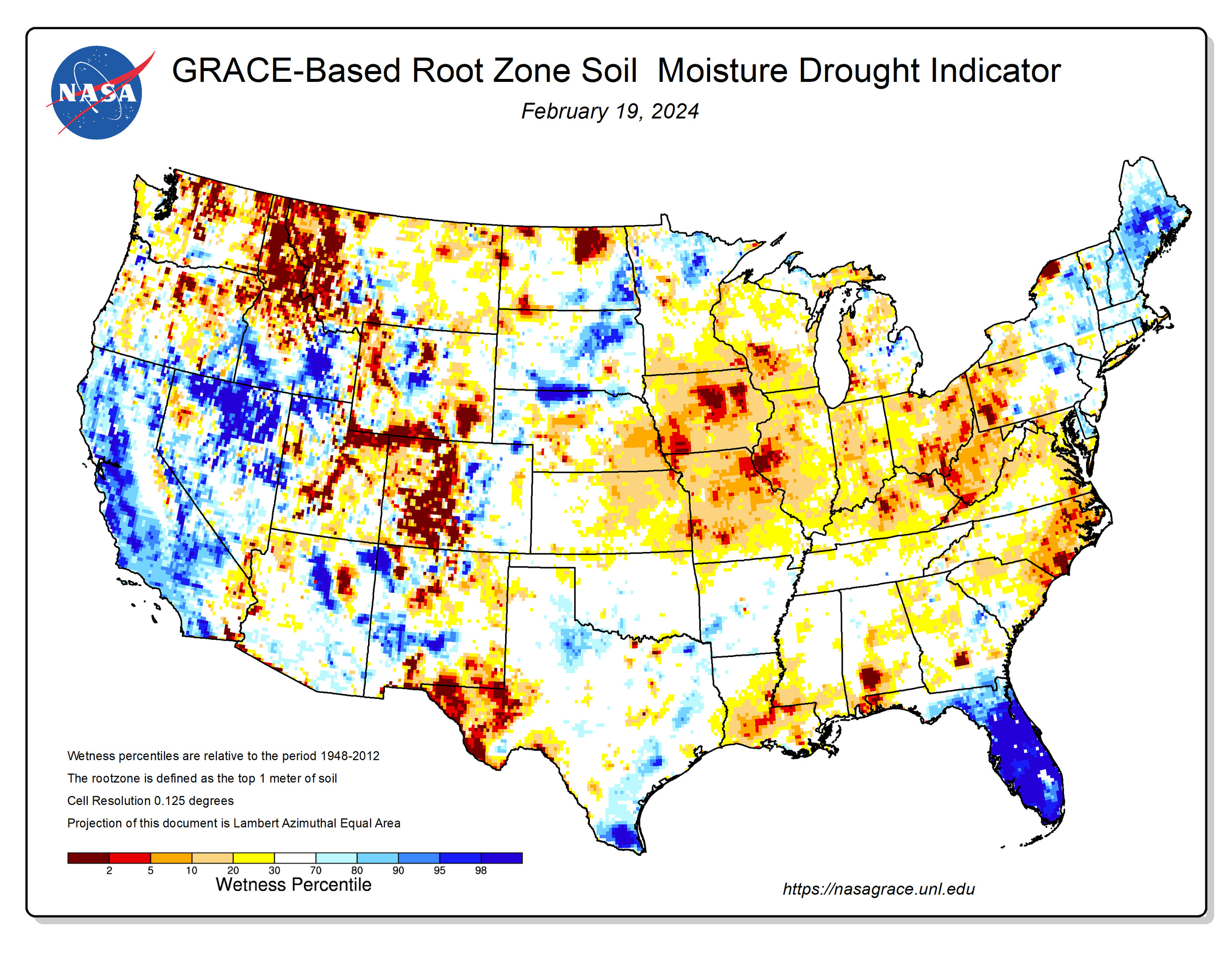
The top meter of our soil is already on the dry side in late February:
So overall here’s my summary for Spring:
1) A warm start in March; cooler weather fairly likely during the 2nd half of month
2) April can go either way temperature wise
3) May is somewhat likely to be the coolest month compared to average
4) There are dry risks in this forecast; a dry spring could be trouble given the early signals we have for summer (more on that below)
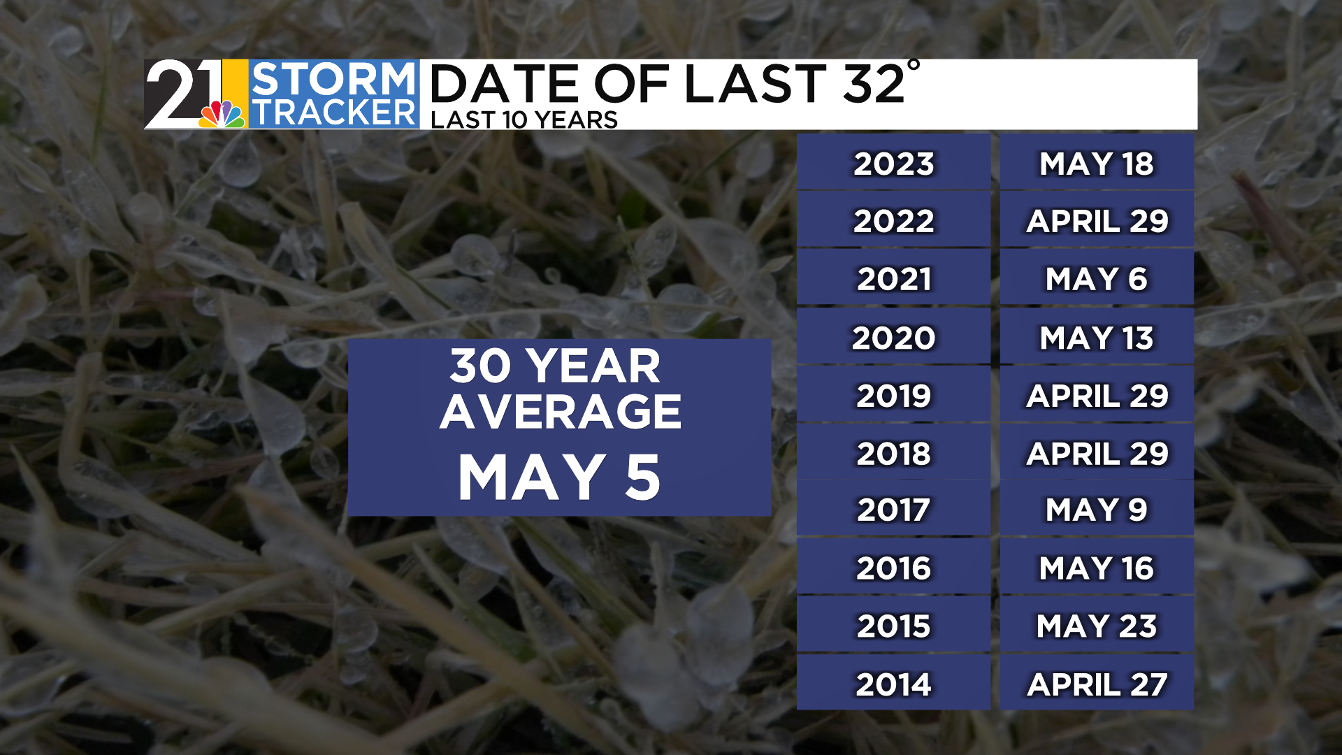
5) A later-than-average frost and freeze is a risk this year
Speaking of freeze risks, here are the stats for the last freeze (32) and hard freeze (below 30) of the season for the YNG airport. There can be localized variations for this kind of thing…sheltered valleys can have a final 32 degree reading well after the airport does.


How About Summer??
I usually say “one season at a time” but we’ll speculate briefly on summer (June-July-August). The tenor of Summer 2024 will likely be governed by how fast El Nino gives way to La Nina (which seems likely). If La Nina comes on hot and heavy by early summer, that increases the dry risks for the heart of growing season. That would not be great if we have ready been through a dry spring.
Model depiction of El Nino giving way to La Nina:

Temperature wise, it is a good bet that we will have a hotter summer than 2023. It’s on the table that it is significantly hotter. The analogs have a pretty toasty signal:

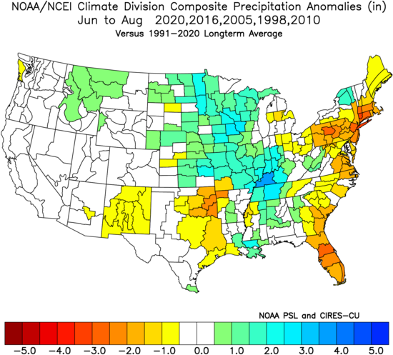
Precipitation forecasting during “thunderstorm season” is tricky business as the next neighborhood over can see 4” from a storm that brings you nothing. But overall there is a dry signal for our region (how dry, as mentioned above, probably depends on the Nino-Nina transition).
It can also be a summer than, while not wet overall, does have higher-than-average chances for severe weather. We’ll focus much more on the summer season later in spring.